Planning Maps Stir Controversy
By Soren Wuerth
TNews Editor
On a mid-week night in early October, a young couple left the Girdwood School after sitting through two hours of presentations laying out options for the community's future.
They moved to Girdwood a little over a year ago, have decent jobs and are outdoorsy. They just want a home to buy.
They said they were frustrated with all the zoning and planning planning particulars, but, also with what they see as a contradiction between a call for affordable housing and resistance to development proximal to existing homes.
Despite a plethora of charts and statistic, "There is a difference between data and what's on the ground", said the young woman near the door, who, along with her husband, declined to be identified.
It's been 28 years since Girdwood has had a comprehensive area plan. In the meantime, a smattering of plans, called "functional" and "specific" by planners, have outlined development prospects.
About 85 residents gathered to hear Huddle's presentation Oct 11. (Photo by Soren Wuerth)
Last year, with an unpopular housing proposal called "Holtan Hills" churning through governmental machinations, the press to update an overarching plan for Girdwood became paramount. The Anchorage Assembly awarded a local organization, Imagine! Girdwood, $140,000 to come up with a new plan.
The group hired an Anchorage consulting firm, Huddle Alaska, to help.
Maps "Show Only Developable Land"
Less than a month ago, Oct. 11, Imagine Girdwood and Huddle revealed two maps that present a broad based plan for development in Girdwood's valley.
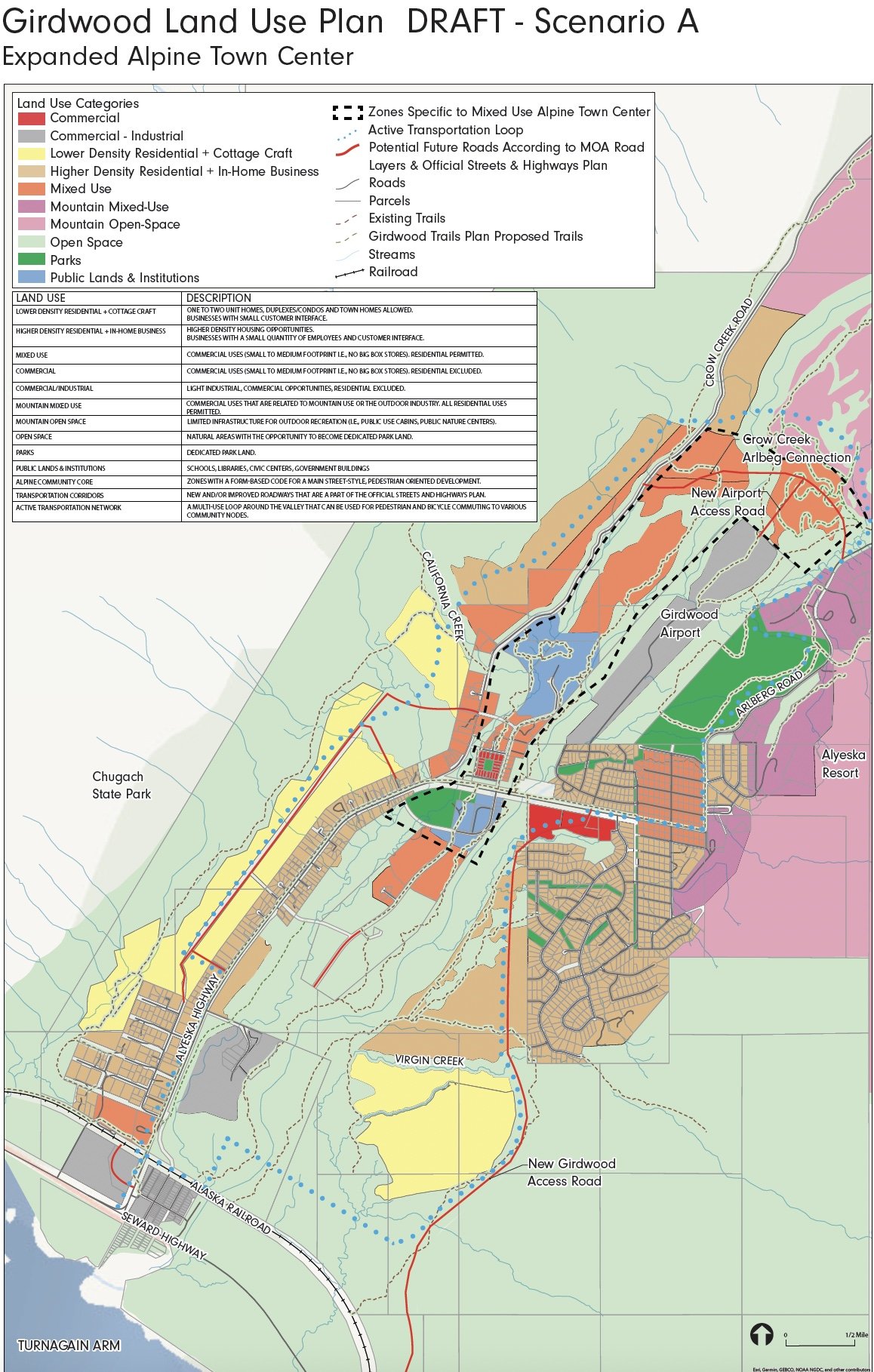
The maps--"Expanded Alpine Town Center" and "Trail Oriented Development"--each contain a cluster of color-coded land use designations encompassing the entire valley and all the land fit for development.
Though areas vary in color, the only places in Girdwood that couldn't see roads, subdivisions, and commercial operations are those lands in floodplains, avalanche paths or property already developed.
When asked at an Oct. 25 meeting whether the maps represent developable land in the valley, Holly Spoth-Torres, of Huddle, confirmed they were.
"In a sense yes," said Spoth-Torres. "The land use shape and categories are based on what would be considered easily developable land, flatter land, outside an avalanche path. In that sense, yes."
She said the maps are based on the 1995 Girdwood Area Plan, and differ from that plan only slightly. A "development reserve" on the older map,
People may think the colorful maps reflect Girdwood's vision as reflected in surveys, meeting comments and testimony, but the maps are really the "point of view from the developer and not the point of view of the values of the community," said Mitch Roth, of Girdwood, who became a director of Imagine! Girdwood last spring.
"[The maps are] the point of view from developer and not the point of view from the values of the community. The way I think about it, from developer's point of view, you can view all the forests along Virgin Creek [as developable], but from my point of view that's not developable. That's a resource that can't be replaced," Roth said.
Where's The Vision?
A powerpoint presentation prepared by Huddle has a slide listing some of the sources for the community's "vision, goals, and policies", but the presentation does not elaborate on how the multi-colored land use designations reflect the sentiments of residents in surveys, community meetings and work sessions.
"I don't know where the [community's] vision fits into the maps. I'm not sure if it ever fits onto the maps," Roth said.
A survey conducted in January 2019 shows that people like Girdwood mostly for, in order, its outdoor recreation, its sense of community and its small town feel.
Residents overwhelming prioritized affordable housing, single family homes and seasonal employee housing over new housing development and construction of multi-family homes. Short term rentals were the least desired housing priority, according to the survey.
Roth said real land use decisions are made in the municipal zoning meetings on the Girdwood Area Plan is adopted by the Anchorage Assembly.
"Someone asked if an area could be permanently protected and the answer was, 'that wouldn't be a land use map decision. That would be another process,'" said Roth.
Some map designations have Girdwood "Looking Like Wasilla"
About 85 residents showed up to the Oct. 11 presentation by Huddle, where residents were told about 100 units are needed in Girdwood and to expect less than one percent population growth per year (though the community's population has been flat over the last decade).
Near the end of the meeting, several locals expressed dismay with the land classifications. Both maps show a "mixed use" preference that includes commercial zoning for a neighbor just below Alyeska Resort and Arlberg Drive with more than existing 100 homes.
"Permanent residents should have the right to keep their neighborhoods as they are," said longtime resident and contractor Ralph Brodin.
Commercial use abutting major roadways on both maps could have Girdwood "looking like Wasilla", said another longtime resident, Larry Daniels.
The comment period on the two maps has been extended to Nov. 5 and can be submitted to holly@huddleak.com.
A map of the Scenario A development plan, or the "Expanded Alpine Town Center". Both maps have an "active transportation loop" (dotted blue line) encircling Girdwood. (Courtesy Graphic)
The Scenario B, or "Trail Oriented Development" map has more "lower density residential housing" (in yellow) than the other map, which has more "mixed us" (orange coloring).


